Jordan

QUINTESSENCE

Insights into signature aspects of the world’s most spectacular places

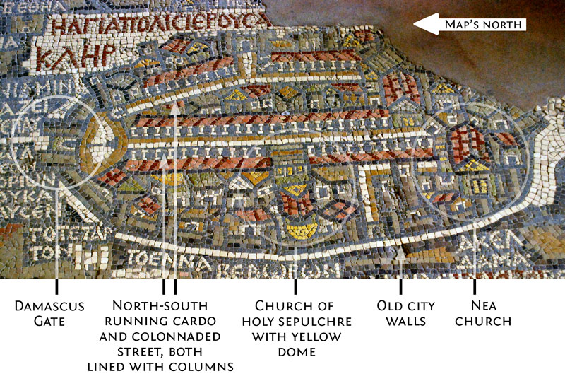
Jordan’s Madaba Map of Jerusalem

By David Raezer

The Byzantine church of St George in Madaba, Jordan, is home to the “Madaba Map,” an impressive — and by far the most well-known mosaic — in the Holy Land.

Layout & Features

  • Location. Created as a floor covering for an early Byzantine church that occupied the position of present-day St George’s Greek Orthodox Church in Madaba, Jordan. Madaba lies along the King’s Highway, a little over 30 km south of Amman.
  • Date. Dating from the second half of the 6th century, the mosaic depicts the geography of the Holy Land at that time. It is the oldest map of the Holy Land in existence.
  • Position in church. It occupies all of the floor space in the apse of the church.
  • Orientation implies Constantinople’s west-to-east viewpoint. The map assumes an oblique perspective, as if the viewer were standing atop a very high mountain and looking eastward (north is on the left). This is interesting since it is the opposite view that a viewer would have from Madaba in Jordan: a viewer in Jordan would look westward for a view of Jerusalem (north is on the right). The eastward vantage suggests that the artist was likely creating the mosaic based on a map prototype that was designed in the West, likely in Constantinople.
  • Key Jerusalem structures. The old city of Jerusalem stands out on the floor-sized map.
    • Sites on the map. In the image above, we have marked the most clearly identifiable structures of the 6th-century city, most of which are still in place today: Damascus Gate, the north-south running Cardo and Colonnaded Street, the Church of the Holy Sepulchre, the old city walls and Nea Church (aka New Church of the Theotokos).
    • The presence of the Nea Church is of particular consequence, as it was not completed until 542. This contributes to the dating of the mosaic to the second half of the 6th century.
    • The famous Temple Mount — the site of the ruined Jewish Second Temple, destroyed in 70 CE (the Islamic Dome of the Rock, which currently stands on the site, would not be built until the close of the 7th century) — is conspicuously absent for reasons unknown.
    • Versus Google Maps. We encourage you to compare the position of these sites with our Google map at right, where we have marked them off.

Compared to Google Maps

Exploring...

Explore Jordan Further!

Exploring...

Get the Guidebook

Exploring...

Please note that some of the links above are affiliate links; as an Amazon Associate, Approach Guides makes a commission from qualifying purchases.